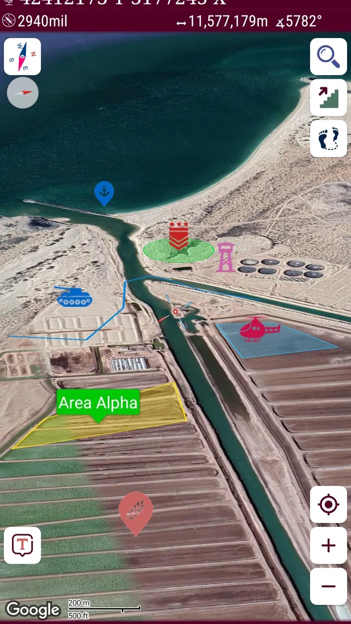
Mgrs & Utm Map Pro: Tactical
- 4.7
- Rating
- 10.00K
- Installs
- $24.99
- Price

 Analysis by App-foxy
I approached Mgrs & Utm Map Pro as a specialist navigation tool rather than as another general map app. Its purpose is clear: it helps users work with military grid references, UTM coordinates, and related position information on a mobile device. That makes it a very different proposition from the familiar map apps most people open for driving directions, restaurant searches, or traffic updates.
My first impression was that this is an app for people who already have a reason to care about coordinate systems. Hikers planning routes, outdoor instructors, search teams, survey-minded users, emergency volunteers, and anyone working from a printed grid map will understand its appeal quickly. If your only need is to find a street address, it is more specialized than necessary. If you regularly receive an MGRS reference and need to turn it into a usable location, the focus becomes much more convincing.
A specialist tool instead of a conventional map replacement
The app sits in the Maps & Navigation category, but it should not be judged by the same standards as a car-navigation product. Conventional map apps are built around visual landmarks, road names, business listings, route suggestions, and spoken guidance. This tool is centered on coordinate work. That difference affects almost every part of the experience, from the information you look for to the way you check whether a result makes sense.
You May Also Like

 Pandora - Music & Podcasts
Pandora’s Music Is Easy to Start, but Harder to Recover
Pandora’s strength is its low-effort path from a seed to a station. Its weak spot is how much confidence it asks you to place in connection, setup, and quiet recovery.

 AccuWeather: Weather Radar
AccuWeather Review: A Quick, Clear Forecast for Everyday Decisions
For everyday plans, the best forecast is the one you can understand quickly. AccuWeather makes rain timing, radar, and local conditions easy to act on, with a few trade-offs.

 Hill Climb Racing
Why Hill Climb Racing Still Turns Crashes Into One More Run
A tiny car, a bumpy hill and one more upgrade: Hill Climb Racing keeps resurfacing because its simple chaos makes every near-miss feel personal.

 AliExpress - Shopping App
AliExpress Makes Global Shopping Feel Personal, but Shoppers Bear the Risk
AliExpress turns a global marketplace into a pocket-sized discovery engine. Its reach is useful, its shopping loop compelling, and its trade-offs easy to miss.

 Lords Mobile: Kingdom Wars
Lords Mobile Is a Kingdom-Building Routine, Not a Quick Match
A case-by-case verdict on the building, battles, device demands, and social commitments that make Lords Mobile rewarding for some players and exhausting for others.

 PDF Scanner app - TapScanner
TapScanner Makes Paperwork Easier to Capture, Check, and Share
TapScanner makes scanning with a phone feel less like a rescue operation and more like a dependable step in getting work done. Its capture tools are useful, though not flawless.
More From Our News Desk
View All News


I found the strongest use case in situations where a location is communicated numerically rather than by an address. A friend may send a grid reference for a meeting point in open countryside. A printed topographic map may show a UTM grid instead of familiar street labels. A field exercise may use MGRS terminology because it is more precise and consistent than saying “the clearing beyond the hill.” In those cases, a standard map app can feel like the wrong instrument, even when it has excellent satellite imagery.
The developer is DakikTech, and the app has been available since April 9, 2018. Its current version is 7.9.26, with Android support beginning at version 8.0. That broad compatibility is useful for people who keep a dedicated older phone for outdoor work, although the age of a device can still affect screen readability, battery endurance, and location accuracy in practical use.
The app is rated 4.7 on average from around two thousand ratings, with more than ten thousand installs. Those figures suggest that it has found a focused audience rather than trying to be a universal navigation platform. I would read that popularity as evidence of relevance to coordinate users, not as a promise that it will suit someone who simply wants everyday turn-by-turn directions.
Why connectivity changes the experience
Connectivity is one of the most important practical questions here, even though coordinate work itself can appear independent of the internet. A phone may know its position through its location hardware, while map imagery, address searches, route context, or other supporting information can depend on network access. I would therefore avoid treating the app as automatically self-sufficient in every environment.
In a strong-signal urban setting, the distinction is easy to overlook. You can check a position, move between map views, and use surrounding online context without thinking much about the connection. On a trail, in a valley, inside a large building, or near a remote work site, the experience can become less predictable. A coordinate may still be meaningful, but the surrounding map context may not be equally available at the moment you need it.
That is why I would prepare before leaving rather than assume that a connection will be present when the task becomes urgent. I would open the relevant area, inspect the coordinate format I expect to use, and make sure I understand the difference between a position I have received and a position my phone is currently reporting. This small preparation step prevents a common mistake: discovering in the field that the important reference is not the part of the workflow causing trouble, while the supporting map information is.
There is also a human factor. When a connection is intermittent, users tend to tap repeatedly, switch views, or re-enter information because they are unsure whether the previous action worked. With a coordinate app, that can introduce avoidable transcription errors. I prefer to pause, verify the displayed result, and compare it with the original reference before acting on it. A clear numerical result is only useful if the digits, zone, and coordinate system have been interpreted correctly.
Using it on a phone in real outdoor situations
The mobile format makes this kind of tool practical because the phone is already the device most people carry into the field. I can imagine using it while walking a marked route, checking a meeting point in a park, or confirming that a paper map and a digital position agree. The value is not only that the phone can show a location; it is that the location can be expressed in the language used by the people or documents involved.
A realistic example would be a volunteer group dividing a search area into grid sections. One person receives a reference from a printed map, another carries the phone, and a third needs a concise position that can be written down or read over a radio. A street-focused navigation app may force the group to translate everything into road names or visual landmarks. A dedicated MGRS and UTM tool reduces that translation step, which can make communication clearer when roads are absent or landmarks are ambiguous.
Another useful scenario is a hiking rendezvous. Suppose the meeting point is not at a named trail feature but near a bend, a shelter, or an open patch of ground. Instead of describing the location with several approximate instructions, the group can work from the same coordinate reference. The app does not remove the need for judgment: terrain, visibility, map datum, and the accuracy of the phone’s location still matter. It does, however, give everyone a more disciplined way to discuss the position.
The screen deserves more attention than it might receive in a quick store visit. Numerical navigation information is easy to misread when the phone is held in bright sunlight, viewed while moving, or checked through gloves. I would stop before recording a coordinate, enlarge my attention to the complete value rather than only the last digits, and repeat it back if another person is relying on it. This is not a criticism unique to this app; it is a practical limitation of using any small phone display for precise field work.
I would also avoid holding the phone in a way that blocks the location signal or treating the first position reading as perfectly exact. A coordinate can look authoritative because it is formatted neatly, but the real-world position may still shift. For navigation decisions, I would compare the reported position with terrain, the printed map, and known reference points. The app is best used as a precise coordinate assistant, not as a substitute for basic orientation skills.
Working with MGRS and UTM without creating errors
The most important preparation is knowing which coordinate system the other person is using. MGRS and UTM are related, but they are not interchangeable strings that can be entered casually. A user who receives an MGRS reference should preserve its zone, band, grid-square information, and numerical precision. A UTM value also needs its zone and hemisphere context. Dropping a leading part or mixing formats can place the result far from the intended area.
This is where I see a less obvious strength in using a dedicated tool: it encourages the user to think about the structure of the coordinate instead of treating every location as a familiar address. Before entering anything, I would identify the format, check the expected region, and compare the resulting position with the broad area described by the sender. If a reference intended for a local trail suddenly appears on another continent, the problem is probably interpretation rather than geography.
Precision is another trade-off. More digits can identify a smaller area, but they also create more opportunities for transcription mistakes. When sharing a position, I would use the level of precision that the situation actually needs and read the value carefully from left to right. For a large meeting area, excessive precision may give a false sense of accuracy. For a narrow search location, reducing the digits may make the information less useful. The right choice depends on terrain, visibility, and the task.
A practical workflow is to keep the original reference visible on paper or in a separate message, enter it once, and then verify the displayed location against the expected zone and surroundings. I would not rely on memory after switching between MGRS and UTM. This is particularly important when several people are exchanging coordinates verbally, because one omitted letter or digit can produce a plausible-looking but incorrect result.
Users should also remember that a coordinate system does not describe every real-world complication. It does not tell you whether a fence blocks access, whether a trail is passable, or whether a map is current. It gives a structured position. The person using it still needs to interpret the landscape and decide whether the destination is reachable and safe.
What happens when the signal or connection becomes unreliable
Failure recovery is not a dramatic feature in a coordinate app; it is a habit. If the network disappears, I would first separate the tasks: am I trying to read the phone’s position, inspect map context, search for a place, or communicate a coordinate? These are different needs, and a problem with one does not necessarily mean the others are working normally.
If a map view does not respond as expected, I would avoid repeatedly changing settings or entering the same coordinate. I would note the last confirmed value, keep the original reference intact, and move to a position with a clearer view of the surroundings if that is safe. In an outdoor situation, a short delay is preferable to wandering while staring at a screen and assuming the latest display is correct.
I would also carry a simple backup: a paper map relevant to the area, a written copy of the meeting coordinate, and enough information to identify the intended zone or region. That is not because the app is uniquely fragile. Phones can lose power, location readings can drift, screens can become unreadable, and network-dependent context can fail across many navigation products. A coordinate assistant becomes much more dependable when it is one part of a prepared workflow rather than the only source of truth.
For group use, recovery is easier when everyone agrees on a format before setting out. Decide whether the team will exchange MGRS or UTM, how much precision is needed, and how a coordinate will be read aloud. This avoids the awkward situation where one person gives a grid reference, another expects a decimal format, and a third assumes that a familiar map app will translate it automatically.
One limitation I would keep in mind is that a specialist coordinate display may feel less forgiving than a consumer navigation app. General-purpose products often explain locations with labels, pins, and visual cues. Here, the user has more responsibility for understanding the numbers. That is a fair trade for precision-oriented work, but it means beginners should practice in a safe, familiar place before depending on it during a demanding outing.
Managing data use and battery expectations
Because this is a mobile maps tool, I would treat data usage as part of planning rather than as a minor technical detail. Map imagery and online context can be more demanding than a simple numerical coordinate, especially when the user repeatedly moves around an area or changes the visible scale. On a limited mobile plan, I would avoid exploring a large region unnecessarily and prepare the exact working area while connected.
Battery planning matters just as much. Keeping a screen active, checking a position repeatedly, and maintaining a location session can consume more power than a short address lookup. In cold weather or on an older phone, the practical endurance may be lower still. I would begin with a charged device, reduce unnecessary screen time, and carry a power bank for longer trips. The app’s low purchase price is not the only cost to consider; the surrounding equipment and preparation determine whether it is dependable in the field.
The app costs $24.99, which places it firmly in the specialist-tool category rather than the casual-download category. I would consider that price reasonable only if I had a recurring need for MGRS or UTM work. Someone who opens a map app a few times a year to find a business or navigate city streets would get better value from a conventional alternative. For a professional, instructor, volunteer, or serious outdoor user, avoiding repeated manual conversion between coordinate formats may justify paying for a focused tool.
Its Everyone content rating makes it broadly approachable from an age-classification perspective, but that should not be confused with beginner-level operation. A young or inexperienced user can open it, yet safe use still depends on understanding coordinates, checking the area, and not assuming that a phone position is infallible. The app can support responsible navigation, but it cannot replace supervision, map skills, or sensible planning in hazardous environments.
How it compares with familiar navigation alternatives
Against a mainstream map app, the difference is specialization. The usual alternative wins for addresses, businesses, traffic, route planning, street imagery, and everyday travel. It is generally easier for a person who thinks in terms of “take me to this place.” This app wins when the input is a grid reference or when a team needs to communicate positions in a formal coordinate language.
Against a dedicated hiking or trail-planning app, the comparison is more nuanced. A trail app may offer richer route discovery, elevation context, community information, or outdoor-oriented visual planning. Mgrs & Utm Map Pro: Tactical is more attractive when the central job is coordinate interpretation and exchange rather than choosing a scenic route. I would not install it expecting a complete replacement for every outdoor planning feature found elsewhere.
Against manual conversion websites or desktop mapping tools, the phone-based workflow is more convenient in the moment. You can work at the location instead of copying a reference into another device. The trade-off is that a phone screen and mobile conditions are less comfortable than a large desktop display, particularly when comparing several points or studying a broad area. For planning at home, a computer may remain easier; for checking a position outdoors, the mobile format is the stronger choice.
The app is therefore not “better” than every alternative. It is better at a narrower job. I would recommend it to someone who has already encountered MGRS or UTM in real work and wants a dedicated mobile assistant. I would skip it for a user who expects spoken driving guidance, automatic local discovery, or a polished street-navigation experience without learning coordinate conventions first.
Who will get the most from it
I think the best audience includes hikers who use topographic maps, search-and-rescue volunteers, outdoor educators, field teams, military-oriented users, and technical workers who exchange coordinates rather than addresses. It can also help a careful beginner who is willing to learn the terminology and test the workflow before using it away from familiar roads.
The less suitable audience is just as clear. If you mainly need commuting directions, public-transport information, restaurant searches, or traffic avoidance, this is the wrong center of gravity. Paying for a specialist coordinate assistant would add complexity without solving your main problem. Even outdoor users may prefer another app if their priority is discovering trails, recording an activity, or following a detailed route with rich recreational information.
My strongest advice is to test the exact coordinate format you expect to receive before an important trip. Use a known location, compare the result with a reliable map, and practice reading the full reference aloud. Then repeat the exercise with the phone’s network connection unavailable or unreliable, not to assume a particular offline behavior, but to learn which parts of your own workflow require preparation. That test will tell you more than a quick glance at the interface.
My connectivity verdict
Mgrs & Utm Map Pro: Tactical makes sense when connectivity is treated as a variable rather than a guarantee. In a connected setting, online map context can make coordinate work easier to understand. In a remote or obstructed setting, the user needs a plan for what must be available, what can be written down, and how a position will be checked if the screen or network becomes unhelpful.
I like the app because it addresses a real gap between ordinary map apps and the way many field teams actually communicate. Its value comes from focus, not from trying to imitate a complete consumer navigation platform. The main friction is that the user must bring knowledge and discipline: recognize the coordinate system, preserve the complete reference, verify the result, and keep a backup plan.
For me, the $24.99 purchase is justified when MGRS or UTM coordinates are part of regular work or serious outdoor planning. The 4.7 average and focused install base reinforce the impression that it serves a defined audience well, but they do not change the basic recommendation. Choose it for coordinate-centered navigation, not for ordinary turn-by-turn travel. Used with sensible preparation, it can be a practical field companion; used as a magic replacement for maps, connectivity, and navigation judgment, it will disappoint.
FAQs for Mgrs & Utm Map Pro: Tactical
01What is Mgrs & Utm Map Pro: Tactical used for?
Mgrs & Utm Map Pro: Tactical is designed for users who need accurate location work with Military Grid Reference System (MGRS), Universal Transverse Mercator (UTM), and standard latitude and longitude coordinates. It can be useful for hiking, land navigation, surveying, outdoor activities, emergency planning, and tactical-style mapping. The app focuses on coordinate conversion, map positioning, waypoint handling, and navigation rather than casual turn-by-turn driving directions.
02Does Mgrs & Utm Map Pro: Tactical work without an internet connection?
The app can generally use your device’s GPS to determine your position without relying entirely on mobile data, which is helpful in remote areas. However, offline availability may depend on whether the required map layers or geographic data have been downloaded or cached beforehand. Before traveling, users should test the application in airplane mode and prepare offline maps, since live map tiles, searches, and some online features may require an internet connection.
03How accurate are the coordinates shown by the app?
Coordinate accuracy depends primarily on the GPS receiver in your phone or tablet, satellite visibility, weather conditions, surrounding buildings, trees, and whether the device has a clear view of the sky. Mgrs & Utm Map Pro: Tactical can display precise grid references, but it cannot make the underlying location signal more accurate than the hardware allows. For critical surveying, military, or emergency operations, verify readings with professional equipment and independent reference points.
04Can I switch between MGRS, UTM, and latitude-longitude formats?
One of the app’s main advantages is its support for different coordinate systems, allowing users to work in the format most suitable for their activity. You can typically view or convert positions between MGRS, UTM, and geographic latitude-longitude coordinates, making it easier to share locations with people using different navigation tools. Users should still check the selected datum, zone, precision, and coordinate order before copying or communicating a position.
05Is Mgrs & Utm Map Pro: Tactical suitable for beginners?
The app can be useful for beginners, but it is more specialized than a standard map or navigation application. New users may need to learn basic concepts such as grid zones, eastings, northings, coordinate precision, map bearings, and GPS accuracy. The interface becomes easier after some practice, especially if you first experiment in a familiar area. Anyone using it for serious navigation should learn traditional map-and-compass skills and avoid relying on one device alone.
Pros
- Accurate MGRS and UTM coordinate display for field navigation.
- Supports offline map use in areas with limited mobile coverage.
- Useful grid overlays make plotting and sharing positions easier.
- Detailed coordinate tools suit military
- hiking
- and surveying tasks.
- Pro version offers a focused interface without distracting social features.
Cons
- Advanced mapping features may take time for beginners to understand.
- Offline map downloads can require considerable device storage.
- Accuracy depends on your phone’s GPS hardware and environmental conditions.
- Battery usage may increase during continuous GPS tracking.
- Some users may find the tactical interface visually dense.

Mgrs & Utm Map Pro: Tactical
Gallery